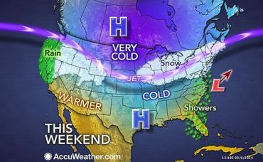
This is the Fallout Forecast for the next 24+ hours for the USA. Slightly milder but wintry weather continues for most of the US, joined by massive snowfall incoming for the Pacific Northwest, and much-needed rain for California.
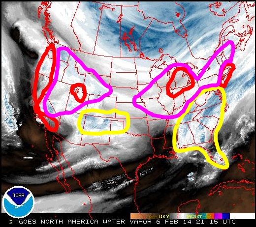
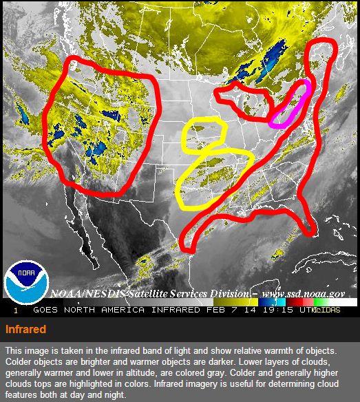
UPDATE: February 7th, 5:00 pm est: Storm intensity increases dictate a large expansion of high risk areas from the map published yesterday, as anticipated. The new map, displayed in infrared, is being used in place of the water vapor loop (as NOAA is running a water vapor loop from January 24th today, for some reason). Also, although rainouts along the Gulf don’t typically show high rads, there has been several higher-then-normal readings around the Gulf coast states over the past 12 hours, which was unexpected. Therefore, high risk extends more southern than what we will often see. In time, as we track the forecast and fallout together on a regular basis it will be more apparent why this is unusual. ~RC
About the map: the fallout risk map is a screenshot of the continental US water vapor analysis at the time of posting. Areas in red indicate a high potential for fallout, areas in pink indicate a medium risk, areas in yellow are cautionary, but low. The areas not covered by a color indicator will essentially be precipitation-free. This map should only be a guide and does not in any way guarantee that your outdoor area is ‘safe’ or ‘not safe’. It simply shows the risk potential, based on a number of weather indicators and atmospheric transport studies.
Storms moving in from the Pacific Ocean are scheduled to drop heavy rain and several feet of snow in parts of California, Oregon and Washington into next week. Heavy snowfall is expected from the Oregon Cascades down into the Sierras from winter storm ‘Orion‘.
 For the rest of the northern tier, the setup is rather complex. According to Accuweather.com instead of one major storm sweeping through the region, there will be smaller storms that can produce light to moderate snowfall. Essentially, the storms will compete with each other until they reach the Atlantic Ocean. Winter Weather Expert Brian Wimer said “Even with the weaker storms, there will still be snow to shovel, roads to treat and travel delays this weekend, centered on the Midwest and Northeast.”
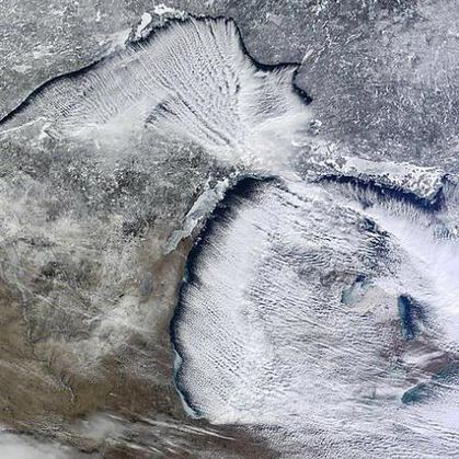
Currently, light snow bands are popping up across lower Michigan, but no where close to the snowfall intensity seen across the Midwest in the past several days. Take for instance Grand Rapids – The city accumulated 87.2 inches of snow so far during the season, making the winter of 2013-14 one of the snowiest in recent memory – if not history, said Mark Sekelsky, a meteorologist at the National Weather Service in Grand Rapids. That number might not seem surprising given this winter’s relentless snows. But for some perspective, GR should be sitting at about 53 inches at this point in the season. The seasonal average is just shy of 75 inches.

The second storm will push across the Midwest later Friday night and on Saturday. This system will bring snow to Chicago, Milwaukee, Indianapolis, Detroit, Cincinnati, Cleveland, Pittsburgh, Des Moines, Iowa, and Omaha, Neb.
It may be necessary to issue the next Fallout Forecast sooner than expected as snow amounts increase and temperatures change. I am also interested in seeing reports from people who own Geigers on the West Coast. I will continue to watch this closely over the next 24 hrs. The complexity of the storms and how they will potentially interact with one another could worsen the storm totals and fallout risks considerably, especially along the East Coast and New England. We also await Geiger reports from the PNW.
To see a further explanation of the history of the Fallout Forecast, and how we determine risk analysis, see the initial post for January, 24th 2014.
For now, stay warm and stay safe! ~Christina


It Seems Our Research Is Coinciding:
Click to access ARkStorm.pdf
LikeLike
Nice work, thanks for sharing ~~ did you see Jim’s Atmospheric River article?
http://theweathereffect.com/2014/02/02/blue-gold-rush-future-water-wars-using-rivers-troposphere/
LikeLike
thanks Christina!
LikeLike
Your welcome Janine 🙂
LikeLike
I love these forecasts.
LikeLike
It’s a whole new way to look at weather. Eventually we need forecasters to get onboard, I’ll talk to anyone who has interest and wants documentation. We had some discussions with The Weather Channel (Mike Bettes) about a year ago, but then he stopped returning my emails
LikeLike
Hey, do you know about Radcast?
Maybe you can coordinate something with them?
https://www.radcast.org/
LikeLike
Yes I’ve been dying to have a conversation with Mimi German. Maybe this week 😉
LikeLike